
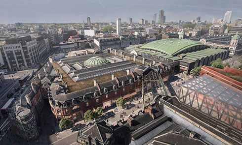


Research for our 2019 Secret Rivers exhibition took many forms: digging into our collections to find suitable objects for display, reading in libraries and archives, speaking to experts, trawling the internet and fieldwork. One of the exhibition curators, Thomas Ardill, tells us about one of the more active forms of research – a run along the route of the Tyburn river.
Now, I’m not a hydrologist, geographer, cartographer or psychogeographer. I didn’t expect to make any new discoveries by visiting London’s rivers or the streets beneath which many of them now flow. But I was keen to at least familiarise myself with the routes of the nine rivers, streams and brooks that form case studies in the Secret Rivers exhibition. I wanted to get a sense of their place (or trace) in the city we know today.
By this time last year, I had already walked along the courses of the Westbourne and Neckinger, taken a boat on the Thames, gone for a dip in the Fleet (well, the men’s bathing pond which drains into the Fleet Sewer), and gone to see the Wandle and the Lea. Running the route of the Tyburn was for me a novel and quick way to experience the buried river. I soon realised that by tracking my progress on a smartphone running app, I could experiment with a new way of mapping a ‘lost river’ and of digitally re-inscribing it into the city. I admit that my run wasn't purely research motivated - it was a week after Christmas and high time I got up off the sofa.
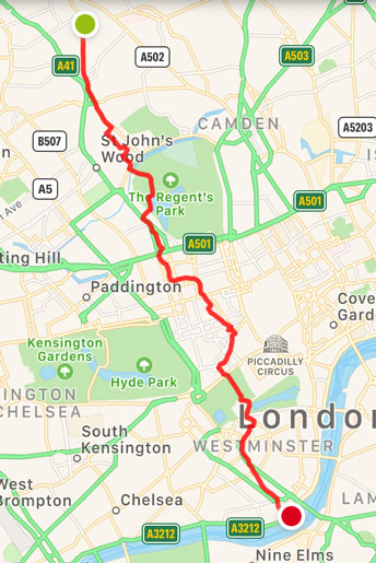
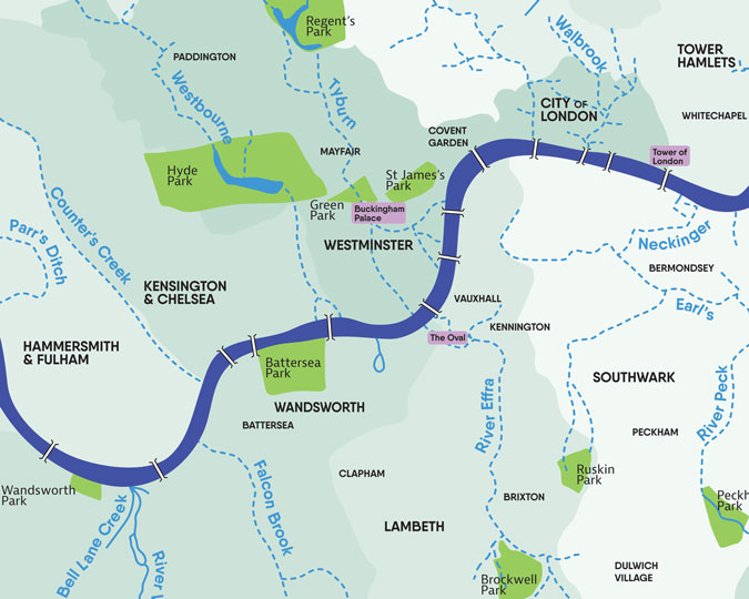
Tom's route along the Tyburn
Planning my street odyssey
I had previously used Tom Bolton’s ‘London’s Lost Rivers: A Walker’s Guide’ (2011) to find my way along the subterranean waterways of the city and I'm sure it would have proved very useful, had I not left my copy on my desk at work.
Instead, I improvised: I found the course of the Tyburn plotted on Google Maps, though it did not have any instructions about which roads were closest to the buried watercourse. With a reckless abandon, I didn't plan a route and instead decided to do my best to follow it as closely as I could through the streets.
The Tyburn has two sources, both of which arise from springs on the southern slope of the Hampstead hills. I ran along the main western arm. My journey there from Belsize Park tube station took me past the eastern stream which starts on Haverstock Hill, so I stopped off there on the way and found a Thames Water manhole cover, which seemed like an appropriate marker for the eastern head of the river.
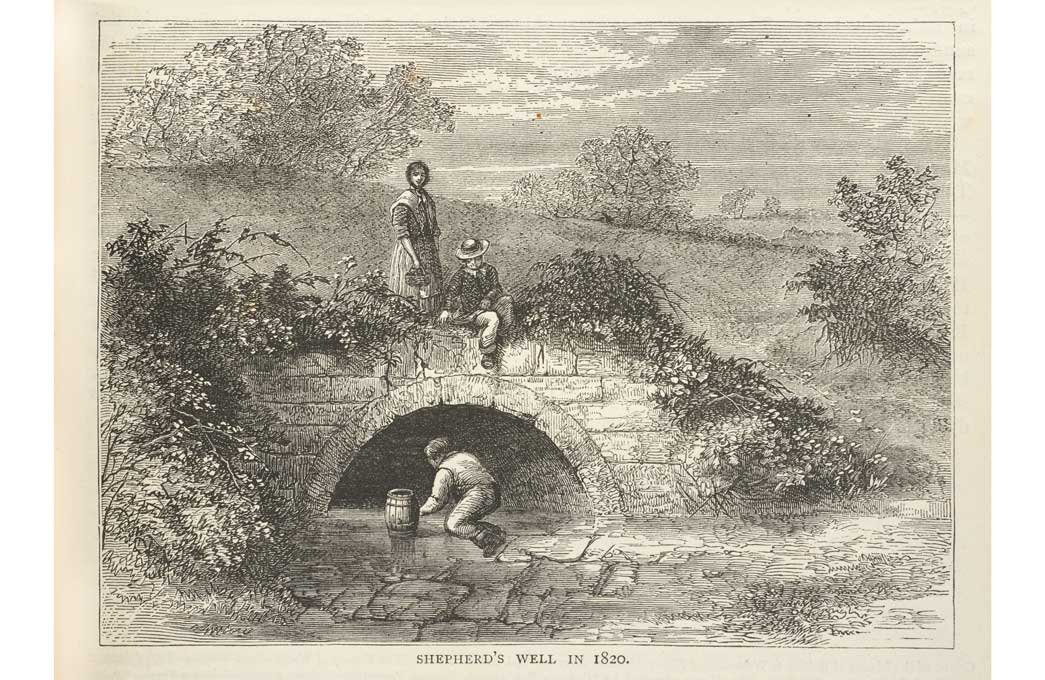
A short walk up the hill and left brought me to the approximate site of the western head: Shepherd’s Well, a former conduit in South Hampstead. Its exact location is lost, but the Londonist suggested the intersection of Spring Path and Shepherd’s Path behind Fitzroy Avenue as an appropriate spot, so I began my run there.
Remnants of a river
A stone plaque on the corner of Lyndhurst Road marks the spot where a drinking fountain provided locals with clean spring water from the Tyburn. The fountain has long gone so I took a swig from my water bottle in remembrance.
Navigating the corners of north London by Swiss Cottage and South hampstead, I headed towards Regent's Park. Whatever beautiful Victorian houses sat at street level, I knew that underneath was a sewer into which the Tyburn was channelled in the 1870s. I paused at the junction of Norfolk and Woronzow Roads to stand on the spot where the eastern tributary of the Tyburn meets the main stream. Zigzagging through a few more residential streets I crossed over Regent’s Canal by Chalbert Bridge which carries the Tyburn in a sewer pipe into Regent’s Park, although there was sadly no sign of it.
Despite running for almost three kilometres, I had little sense of the river since leaving the fountain plaque. I had higher hopes for Regent’s Park, however, as I knew that the Y-shaped boating pond had originally been filled by the Tyburn and another smaller tributary arising just below London Zoo to the east. The lake – a haven for ‘nearly 1,400 recorded species’ of wildlife, according to a nearby nature board – has, since the 1830s, been fed with clean water from boreholes rather than the Tyburn, but the river still flows beneath it in a pipe. I stopped on the bridge by the island at the top of the pond to look out for some of the famed wildlife and was lucky enough to catch a heron fly by. No sign, however, of the wild brown trout or salmon that the Tyburn Angling Society hope to catch, should it one day be restored as London’s ‘premium salmon fishing river’
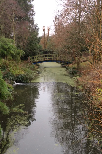
A view of the bridge in Regent's Park
I left the park by the western exit and picked up the Tyburn once more at Changford Street. Always alert to riverine clues, I wondered if there had once been a ford here. I later checked on some old maps but it seems that the cobbled street had originally been called New Street Mews, so the name was mere serendipity. I did, however, catch my first sight of the river through a circular drain cover on the intersection with Ivor Place.
The grid pattern of Marylebone largely obliterates the course of the Tyburn until Blandford Street (another coincidental ford) takes a slight turn near Aybrook Street, named after the Aye or Eye Brook, a local name for the Tyburn. Following Blandford Street into Marylebone Lane I finally began to feel the meander of the river. These streets were built over the river path and so follow the shape of its banks. The lane has recently been repaved with varying shades of granite setts (cobbles) to evoke water, a nice, if subtle, reminder.
The river meets central London
Dodging the Christmas sale shoppers I crossed over Oxford Street by Bond Street station, noting the slight rise where the stream was bridged over by Tyburn Road, named after the gallows to which it led, rather than the river. Continuing down South Molton Lane I hoped to pop into Greys Antiques to see the stream in the basement, but it was unfortunately closed. Greys claims that this is a section of the Tyburn, but unless the goldfish are swimming in sewage it must be fed by a local spring. We know that there are good supplies of fresh water around here as in 1238 the City of London was granted a lease to build a conduit to provide drinking water from Stratford Place to Cheapside via today’s Trafalgar Square, along the Strand and over the Fleet Bridge (and the already-polluted River Fleet) to the City.
Continuing down South Molton Street and crossing over Brook Street (no coincidence) it is possible to follow the wide arc of the Tyburn around Mayfair towards Green Park. The red line traced by my running app betrays the numerous right angles that runners are obliged to take to cross roads as well as the mistake I made at Bloomfield Place and a mad squiggle where I stopped at the intersection of Landsowne Row and Curzon Street to film the Tyburn through another drain cover.
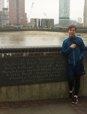
Tom stands by a plaque marking the Tyburn's outflow into the Thames
The plaque lists the course of the Tyburn through Shepherds Well, Belsize Park, Swiss Cottage, Regents Park, Marylebone, Oxford Street, Mayfair, Green Park, Westminster, Pimlico and Tachbrook Street to the River Thames.
Running across Green Park I got a sense of the stream flowing downhill in a slight dip towards Buckingham Palace where it is thought that the Tyburn may once have split into two channels; one going east towards Westminster (where it may have split again to create Thorney Island) and the other heading south through Victoria towards Vauxhall Bridge. I took the southern branch as that's the route followed by the sewer network, and I can't get enough of sewers.
I had little sense of the stream as I navigated through Victoria, weaving in and out of the streets and passages that lie close to the Tyburn’s course. The final kilometre and a half, however, offers a satisfying sense of running over the open sewer that the Tyburn was channelled into during the eighteenth and nineteenth centuries. King’s Scholar’s Passage is named after the King’s Scholars’ Pond Sewer over which it was built. The sewer continues under Tachbrook Street where I spotted it for a third time through a manhole cover, and along Aylesford Street, a reference to the ford over the Aye Brook.
Onwards to the Thames
Through the Tachbrook Estate, I bounded, and over Grosvenor Road where I spotted the plaques on Rio Cottage ‘Built 1832 as part of Kingschoole Sluice’ and ‘Tyburn House’ next door. To the right, an open gate leads on to the Thames Path where a stone is inscribed with the route of the River Tyburn and marks its outflow into the Thames. The tide was low and I could see the muddy foreshore although no water seemed to be flowing out of the opening beneath Rio Cottage; presumably it had all been intercepted by Northern Low Level Sewer which carries sewage diluted with rain water east to treatment works at Beckton. I therefore extended my run a little onto Vauxhall Bridge so that I could see the mouth of the Tyburn in the large opening in the river wall.
I had finished my run and my water so there was nothing to do but head back across the road for a pint at the Grosvenor pub (almost directly above the stream) with which to quench my thirst and toast the Tyburn.
Secret Rivers closed in October 2019.